Atlas Morocco Map & Guide: Valleys, Passes, and Kasbahs
If you’ve ever tried to picture Morocco on a blank sheet of paper, the first thing that jumps out is the dramatic spine of the Atlas Mountains. They are more than a backdrop; they are a living, breathing network of valleys, mountain passes, and ancient kasbahs that shape daily life for the 3 million people who call this range home. In this guide I’ll walk you through an Atlas Morocco map you can actually use on the road – highlighting the most photogenic valleys, the safest passes for drivers, and the hidden kasbahs that still whisper stories of Berber warriors. Whether you’re planning a short day‑trip from Marrakech, a multi‑day trek, or simply want to understand the geography before you set foot on the trail, this article gives you a practical, on‑the‑ground perspective that no generic atlas can provide.
Table of Contents
Table of Contents
Why a Specialized Atlas Morocco Map Matters
Most world atlases compress the Atlas Mountains into a thin gray line, but the reality is a mosaic of micro‑climates, river canyons, and terraced farms. A dedicated Atlas Mountains Morocco map shows:
- Elevation changes in 100‑meter intervals – essential for planning altitude‑related acclimatization.
- Unpaved mountain roads and seasonal closures, so you won’t end up stuck behind a herd of goats.
- Locations of atlas villages map points, from the bustling market town of Imlil to the remote stone houses of Aït Bouguemez.
Having this level of detail lets you decide where to camp, which passes are drivable in winter, and where the best photo spots are without spending hours on Google Street View.
How to Read the Atlas Morocco Map
1. Colour Coding for Altitude
- Green (0‑800 m) – Coastal plains and lower valleys; expect warm days and occasional night breezes.
- Yellow (800‑1,600 m) – Mid‑altitude plateaus; temperatures start to dip, especially after sunset.
- Orange (1,600‑2,400 m) – High valleys like the Ourika; cooler days, potential for sudden rain.
- Red (2,400 m + ) – Peaks and passes such as Tizi n’Tichka; snow is common in winter, and the air feels thinner.
2. Symbol Legend for Passes and Roads
- Solid white line – Paved national road (e.g., N9).
- Dashed white line – Gravel or paved secondary road.
- Red triangle – Mountain pass; altitude listed next to the symbol.
- Blue dot – River crossing or bridge – useful for spotting water sources on a trek.
3. Icons for Kasbahs and Historical Sites
- Brown square – Restored kasbah (often open to visitors).
- Grey circle – Ruined fortification – may be on private land, so ask locals before exploring.
The Main Valleys You Must Explore
Ourika Valley – The Green Ribbon of the High Atlas
Just an hour’s drive south of Marrakech, the Ourika Valley is the first major dip you’ll see on any atlas morocco map. It follows the Ourika River through pine‑forested slopes, ending at the dramatic Setti Fatma waterfalls.
What to do:
- Hike the 4 km trail to the fifth waterfall – a family‑friendly walk that offers a cool dip in natural pools.
- Visit the traditional Berber market in the village of Imlil (peak altitude 1,740 m).
- Grab a tagine at a family‑run restaurant – the goat cheese you’ll taste is made on the spot.
- You can easily pair Ourika with some of the classic day trips I list here.
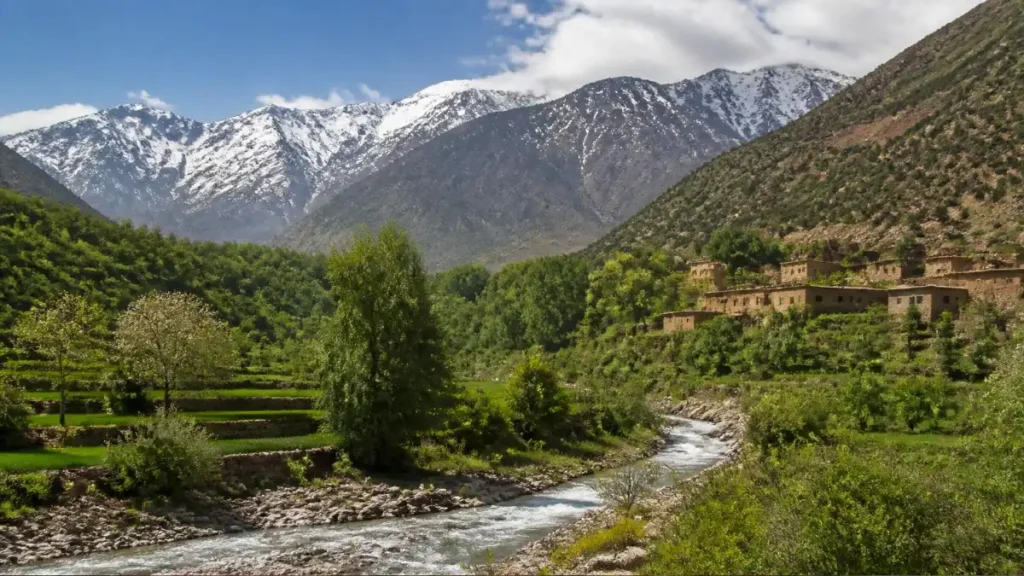
Aït Bouguemez (The “Happy Valley”) – A Photographers’ Dream
Nestled between the Toubkal and M’Goun massifs, Aït Bouguemez is a broad, verdant bowl that appears on every atlas villages map for its vibrant orchards and terraced fields.
Highlights:
- The blue‑white houses of the village of Tifoultoute, perched on a cliff edge.
- A sunrise trek to the hidden lake of Tislit – the early light turns the water into a mirror for the surrounding peaks.
- A chance to stay in a traditional guesthouse where you can learn to make “khobz” (Berber flatbread) with the family.
- For longer treks around M’Goun and the High Atlas, I detail stages and refuges in my trekking Atlas handbook.
Dades Gorge – The Red Canyon of the Middle Atlas
If you follow the atlas morocco map eastward, you’ll hit the Dades Gorge, a spectacular canyon cut by the Dades River. The road winds through sheer red rock walls, offering countless pull‑outs for photo stops.
Don’t miss:
- The “Monkey Fingers” rock formation – a natural arch that frames the river perfectly.
- A short hike to the Ouzoud waterfalls (though technically in the High Atlas, they’re often accessed from the Dades route).
- Sunset at the Kasbah of Tamnougalt, a well‑preserved fortress that now houses a small museum on local crafts.
Essential Passes for Drivers and Trekkers
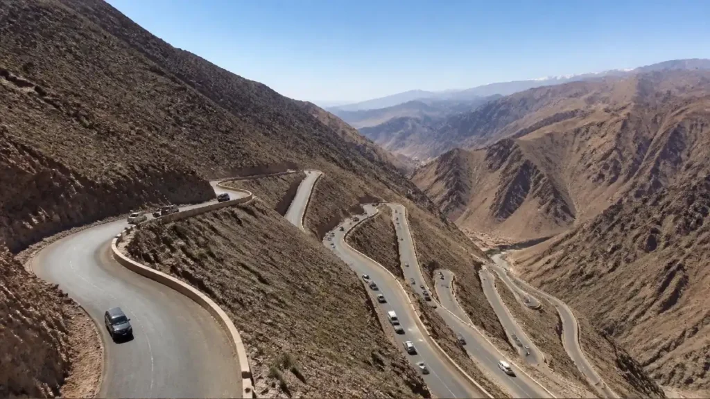
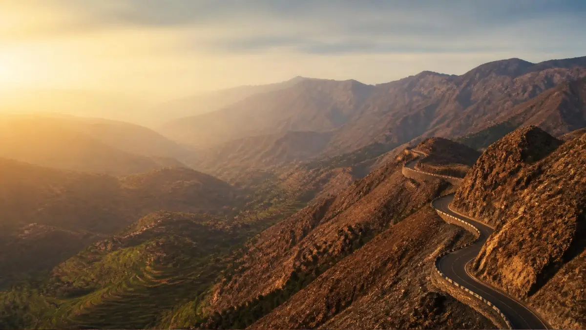
Tizi n’Tichka (2,260 m) – The Gateway to the Sahara
The most famous pass on the atlas mountains morocco map, Tizi n’Tichka connects Marrakech with Ouarzazate. It’s a 30‑kilometre stretch of hairpin bends that can be intimidating in winter snow, but the view of the desert‑like plateau below is worth every turn.
- Best time to cross: Late spring (April‑June) or early autumn (September‑October) when the road is clear and the temperature is moderate.
- Safety tip: Keep fuel topped up; there are no service stations for 120 km on either side of the pass.
Tizi n’Isly (2,200 m) – The Quiet Alternative
Often overlooked, Tizi n’Isly runs parallel to Tizi n’Tichka but stays on the northern side of the range. It’s less travelled, which means fewer potholes and a calmer driving experience.
- Why choose it? The pass offers spectacular views of the Ait Ourir valley and a glimpse of the Berber villages that dot the ridge.
Col de la Tache (2,400 m) – For the Adventurous Trekker
If you’re planning a multi‑day trek, the atlas villages map shows the Col de la Tache as a high‑altitude crossing between the M’Goun and Toubkal massifs. This route is only suitable for experienced hikers with proper acclimatization.
- Key features: Glacial cirques, alpine flora, and occasional sightings of the elusive Barbary macaque.
Kasbahs You Can Actually Visit
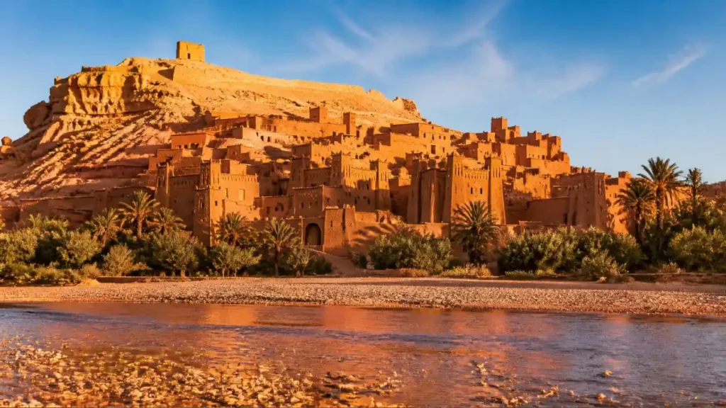
Kasbah Aït Benhaddou – A UNESCO Icon
Located on the caravan route between Marrakech and Ouarzazate, Aït Benhaddou is the poster child of Moroccan kasbahs. The red‑clay walls rise dramatically from the desert floor, and the site has hosted countless Hollywood movies.
- How to get there: Follow the atlas morocco map north from Ouarzazate on the N9, then turn onto the road marked “Kasbah Aït Benhaddou.”
- Visitor tip: Arrive early in the morning to avoid crowds and capture the golden light that makes the earthen walls glow.
Kasbah Tifoultoute – Hidden in the Happy Valley
While many tourists flock to Aït Benhaddou, the atlas villages map also points out Kasbah Tifoultoute, a smaller but beautifully restored fortress perched above the Aït Bouguemez valley.
- What to see: A small museum of traditional pottery, and a rooftop terrace with panoramic views of the surrounding almond orchards.
Kasbah of Telouet – The Forgotten Palace
High up on the Tizi n’Tichka route, Telouet was once the seat of the powerful Glaoui family. Its intricate cedar‑wood ceilings and mosaics are surprisingly intact despite the remote location.
- Access: The atlas morocco map shows a narrow dirt road branching off the main highway near the village of Telouet. A 4×4 is recommended.
Practical Planning Tips
When to Visit the Atlas Mountains
| Season | Temperature (°C) | Road Conditions | Best Activities |
|---|---|---|---|
| Spring (Mar–May) | 12–22 (valleys) | Mostly clear, occasional rain | Wildflower hikes, river walks |
| Summer (Jun–Aug) | 8–18 (high alt.) | Dry, dust on unpaved roads | Trekking, star‑gazing |
| Autumn (Sep–Nov) | 10–20 | Good visibility, cooler nights | Photography, cultural festivals |
| Winter (Dec–Feb) | –2–10 (passes) | Snow on Tizi n’Tichka, possible closures | Snow‑shoeing, ski at Oukaïmeden |
What to Pack for an Atlas Mountains Adventure
A comprehensive checklist is essential – I recommend reading my full Morocco packing list 2026 for a detailed checklist. In short, bring:
- Layered clothing (thermal base, fleece, waterproof shell)
- Sturdy hiking boots with ankle support
- Sun protection (hat, SPF 50, sunglasses)
- Reusable water bottle + water‑purification tablets
- Portable power bank – cell service can be spotty in high valleys
Getting Around
- Car rental: Choose a 4×4 if you plan to tackle Tizi n’Tichka or any off‑road tracks.
- If you’re comparing 4×4 prices, I usually tell guests to start with a car search engine rather than walking up to a random desk at the airport.
- If you’re renting a car, double-check that your travel insurance covers rental excess and off‑paved roads – I explain what to look for in my Morocco travel insurance guide.
- Public buses: The CTM and Supratours lines run between Marrakech, Ouarzazate, and Agadir, but they rarely stop at small villages.
- Guided tours: For a hassle‑free experience, check out my trekking Atlas mountains Morocco 2026 guide, which includes itineraries, local guides, and accommodation options.
Sample Itinerary: 5‑Day Road‑Trip from Marrakech
- Day 1 – Marrakech → Ourika Valley (30 km) – Overnight in a guesthouse in Imlil
- Day 2 – Imlil → Aït Bouguemez (120 km, via Tizi n’Isly) – Explore Tifoultoute, stay in a traditional house
- Day 3 – Aït Bouguemez → Dades Gorge (150 km, cross Tizi n’Tichka) – Sunset at Kasbah Tamnougalt
- Day 4 – Dades Gorge → Ouarzazate – Visit Kasbah Aït Benhaddou and film studios.
- If you prefer not to drive, you can also book Atlas and kasbah day tours from Marrakech and Ouarzazate through reputable platforms.
- Day 5 – Ouarzazate → Marrakech (200 km) – Stop at Telouet Kasbah on the way back
You can find more day‑trip ideas in my article on the best day trips from Marrakech – perfect if you only have a weekend to spare.
Environmental Responsibility
The Atlas Mountains are fragile ecosystems. When you travel:
- Stick to marked trails – stray off‑road can cause erosion on steep slopes.
- Carry out all trash; there are few waste bins in remote villages.
- Respect local customs – ask permission before photographing people, especially women. For more cultural do’s and don’ts across the country, see my Morocco safety guide.
For official tourism information, visit Visit Morocco and check the latest guidelines on protected areas.
Wrap‑Up: Your Next Step
Armed with a detailed atlas morocco map, you now have the tools to navigate valleys, conquer passes, and step inside centuries‑old kasbahs with confidence. The mountains are a living museum; every turn reveals a new story, a new flavor, a new friendship.
Ready to turn this guide into a real adventure? Browse the trekking Atlas mountains Morocco 2026 page for ready‑made routes, or start planning your own custom itinerary using the map tips above. The Atlas is waiting – let’s uncover its hidden corners together.
FAQ: Atlas Morocco Map & Guide
What is the best time of year to drive the Tizi n’Tichka pass?
Late spring (April‑June) and early autumn (September‑October) offer clear roads, moderate temperatures, and spectacular scenery without the winter snow closures.
Can I visit Kasbah Aït Benhaddou without a guide?
Yes, the site is open to the public and has clear signage in French, Arabic, and English. Guided tours are available if you want deeper historical context.
How many days do I need to trek the High Atlas from Imlil to Toubkal?
A typical ascent of Mount Toubkal (4,167 m) takes 2 days (overnight in a refuge) plus 1 day for descent, but many hikers add an extra day to explore surrounding valleys.
Are there reliable mobile networks in the high valleys?
Coverage is generally good in larger villages like Imlil and Ouirgane, but it can be spotty in remote hamlets above 2,000 m. A local SIM card purchased in Marrakech provides the best overall service. I compare the main operators and best eSIM options in my 2026 SIM card guide if you want to be connected on mountain roads too.
Do I need a visa to travel through the Atlas Mountains if I’m a European citizen?
No. Morocco offers visa‑free entry for EU citizens for stays up to 90 days. Just bring a passport valid for at least six months.